On Sunday, May 22, 2011, an EF5 tornado touched down in Joplin, MS. Fueled by the wrath of winds in excess of 200 mph and spanning ¾ of a mile wide, the tornado blew across a 6-mile trajectory before dissipating, rendering it one of the deadliest and most damaging tornadoes in U.S. history.
The storm left a path of death, rubble and carnage, and the area is still being rebuilt to this day. It’s this rebuilding process that Ashley Maupin, an Ohio University undergraduate studying Geographic Information Sciences and Meteorology, is tracking. Via satellite imagery, Maupin can determine just how powerful this tornado was, how much damage it did, and how much rebuilding has yet to be done.
Maupin presented her research April 9 at the 2015 Ohio University Student Expo, where she won a second-place prize for her work. She would like to see it used as a model for local governments for extreme weather preparedness.
First Take
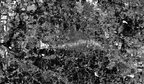
This is thermal imagery Maupin used to track the tornado’s damage. The image was taken by The U.S. Geological Survey on July 22, 2014, and analyzed via ENVI radar analysis technology. The tornado starts from the right side of the image and travels across the snake-like line of smothered buildings, homes and infrastructure. According to Maupin, the tornado leveled roughly 9,000 homes, damaged roughly 4,000 others, and damaged or destroyed 550 businesses. The tornado killed an estimated 157 people, according to the National Oceanic and Atmospheric Administration.
Three Years Later
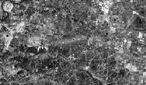
This is a zoomed in photo of the same area taken more than three years later.
“Clearly, you can still see the path,” Maupin says of the horizontal streak of gray, indicative of the tornado.
Putting It All Together
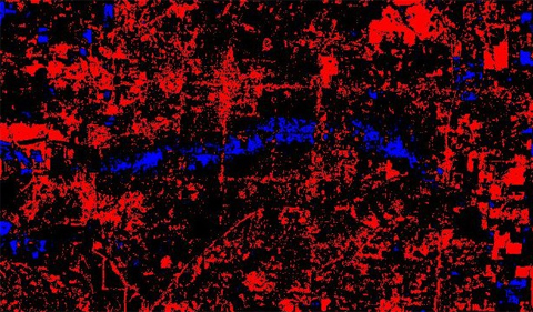
By comparing satellite images from July 2011 to others from October 2014, Maupin created an image that shows the physical differences between the two photos. In the analysis, black represents areas that have not changed since the tornado, red represents areas that have undergone some change, and blue indicates areas that experienced a lot of change. This picture not only gives an idea of the path of the tornado, but of what areas have been rebuilt, what areas still need work done, and which areas have been abandoned.
Looking Forward
Maupin, who was advised on the project by Dr. James Lein, Professor of Geography, will graduate in May. She hopes to attend graduate school for a natural hazards or environmental assessments program, and she would like to expand on her remote sensing research for her thesis.
Now that she has the geographic data, Maupin plans to find out what role socio-economics play in the rebuilding of the area.
“A lot of the residential areas have not been rebuilt because of the poverty level,” Maupin says.
According U.S. census data, 19.2 percent of Joplin lives below the poverty level.
Following the tornado, Joplin residents had to make the difficult decision between leaving the area or rebuilding in the heart of tornado alley. According to Maupin, between Jasper and Newtown County (Joplin is split between them), there have been 80 tornadoes since 1950.
In this intersection between devastating natural disasters and economic distress, Maupin plans to continue monitoring the regrowth of the Joplin area, potential preventative measures to be taken, and whether Joplin residents will continue to rebuild or move to a less tornado-prone area.
Tornado images courtesy of Ashley Maupin.


Comments