
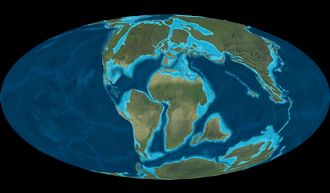
Plate positions at the end of the Cretaceous Period, the time of the mass extinction that wiped out the dinosaurs. DeepTime Maps ©2016
Dr. Alycia Stigall, Professor and Chair of Geological Sciences, was awarded the 1804 Special Library Endowment Fund to support the acquisition of three series of paleogeographic maps produced produced by Dr. Ron Blakey and distributed through Deep Time Maps.
Through this purchase the full set of global, North American, and European reconstructions from the present day to more than 500 million years ago are available for use to the Ohio University community. Access is available for anyone with a valid OHIO ID via the ALICE record links:
- Global paleogeography and tectonics in deep time
- North American Key Time-Slices
- Paleogeography of Europe
Paleogeographic maps represent the location of the Earth’s tectonic plates and landscape characteristics at time slices over the past 600 million years of Earth’s history. These maps depict key information such as the location of plate boundaries, position of ancient oceans, location and extent of mountain belts, and deserts. The maps available through Deep Time Maps are the highest quality reconstructions that are designed for both research and teaching purposes.
To produce paleogeographic maps, data from a wide variety of sources are combined. This includes paleomagnetic pole data, sedimentary data, fossil occurrence data, and igneous and metamorphic rock information. The paleogeographic reconstructions summarize this broad suite of data. These maps are commonly used as the base for figures in journal articles, research presentations, and teaching.


Comments