
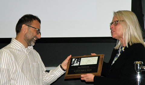
Department chair, Dr. Dorothy Sack on right, presents Ray Postolovski with a plaque commemorating the naming of Bloemer Berg near Athens.
Geography alum Ray Postolovski recently returned to campus to commemorate the contributions of late Geography professor Hugh Bloemer to the Geography Department and the Ohio University community.
Postolovski led the effort to designate the summit near Athens as Bloemer Berg. This naming was approved by the U.S. Geological Survey and has been entered into the Geographic Names Information System. While visiting Athens on Nov. 17, Postolovski shared some reflections on his career path, changes in his field, and his memories of the Ohio University Department of Geography.
Postolovski’s career has spanned the private and public sector. For 18 years, His consulting work helped firms build, grow and capitalize on their geospatial investments. Since 2009, he has worked for the USGS’s National Geospatial Program, where he leads a team dedicated to improving the nation’s geospatial surface water data. These data include the National Hydrography Dataset and Watershed Boundary Dataset, digital geospatial datasets that map the surface water of the United States and are a part of the National Map. The NHD represents the nation’s drainage networks and related features including rivers, streams, canals, lakes, ponds, glaciers, coastlines, dams, and streamgages. These datasets are used primarily to support science and creating cartographic products.
Postolovski sees a lot of dynamism in careers that engage with geospatial technologies. He sees a demand for geospatial information science (GIS) graduates who are focused problem-solvers and dedicated to updating their skill sets as new needs emerge.
“Our field is constantly evolving due to changes in technology and urgent nationwide needs,” he said. “For example, we have a goal of obtaining nationwide LiDAR coverage through our 3D Elevation Program (3DEP) and providing this data to anyone who is interested in creating derived products from it.”
He has many fond memories of his student days in the Geography Department.
“My most fond memories as a Geography student was the camaraderie we had with our fellow classmates and teachers. We truly worked together to help each other succeed. The Geography faculty at Ohio University was by far the most caring and helpful in developing their students,” he said.


Comments